
A two-week canoe trip through the Discovery Islands on Canada's west coast
- reason2reisen
- Apr 1, 2023
- 9 min read

Updated: Aug 21, 2023

As our time in British Columbia (BC) drew to a close, we embarked on a thrilling adventure that would take us around the Discovery Islands for two weeks. Our group of nine included friends and family members with varying levels of canoeing experience. Liam had already planned and executed several canoe trips on the BC coast in the last few years, so we knew we were in good hands.
The Discovery Islands are part of an Archipelago between Vancouver Island and mainland British Columbia. There are small communities with regular ferry services on a couple of the islands, but apart from the occasional fishing lodge or mansion, they remain mostly uninhabited. Like most of BC’s coast, the Discovery Islands are teeming with marine life. It is commonplace to see eagles, whales, dolphins, seals and sea lions and all kinds of less majestic creatures while canoeing along. Especially in the later summer and fall, when the salmon come back to spawn, many animals are attracted by such a plentiful and nutrient rich food source.
What makes the Discovery Islands unique are the sunny weather and the tidal currents. As the tides rise and fall in the surrounding fjords and bays, all that water is pushed through the channels between the Discovery Islands. At especially narrow or shallow points, tidal rapids form every 6 hours, alternating direction as the tide flows in and out. This is great for wildlife as the water is constantly oxygenated and nutrients are churned around, but it creates a unique hazard for boaters, and it is very important to come prepared when paddling among the Discovery Islands.

Route planning 🗺️
Although there may be more modern alternatives available, we love using the giant paper nautical charts for planning ocean paddling trips. It was pretty fun to pore over the charts spread all over our living room planning out campsites and routes. One of our favourite strategies to find potential campsites or sites of interest is to read through trip reports and blogs in the area and record potentially useful information.
We marked down all the promising campsites on our paper charts and colour-coded them based on whether they were paid or free and how nice they seemed.
Tidal Rapids 🌊
Not to be underestimated on a tour of the Discovery Islands are the tidal rapids. Some of the most notorious rapids in the Discovery Islands include the Yuculta Rapids, Dent Rapids, Greene Point Rapids, Arran Rapids, Gillard Passage Rapids and the Okisollo Rapids. You definitely don't want to traverse them at anything close to max flow, as currents can reach 7 knots, complete with whirlpools and waterfalls. The freely available charts published by Canadian Hydrographic Service are invaluable for route planning, and they even publish current tables for all the forementioned rapids.
In canoes, we wanted to make sure we passed through the rapids at as close to slack current as possible (when the tide is switching directions) and we planned the timing of our trip around the traversal through Dent and Arran Rapids. We chose the day of the month on which there was the least current at those 2 rapids and made sure we crossed through Arran within the 30-minute window of most slack current. Keep in mind, current charts are not as exact as tide charts and can be off by as much as 15 minutes. Tide and current tables are available from the government of Canada’s website here.
Itinerary 📆
The day before our departure, we all gathered at Sayward Fisherboy RV Park Motel and Resort, eager to start our adventure. As the rain poured down outside, we spent the evening huddled inside repacking our gear and food to ensure everything was adequately waterproofed and evenly distributed. We did some food portioning math and left behind any excess food that we deemed unnecessary for our journey.
We had booked a couple of cabins at the RV Park and it was nice to start the trip with dry tents. We gathered around to go over the route options and decided on a plan for the first couple of days, at least until we were safely through Arran Rapids.
It was still raining the next morning, but that first day was surprisingly the wettest of our whole trip. Our 2 weeks of sun and blue skies is very unusual for paddling on the BC coast, where we usually assume that at least 1/3 of the time it will be raining. However, sunny weather also meant afternoon winds due to local convection currents.
Our choice to begin our journey at Elk Bay recreation site was due to its free parking and nice campsites for our trip's final night. Unfortunately, we got a flat tire on the gravel road leading to the site. This unexpected delay caused us to push our start time back to late afternoon, but we were determined to hit the water and begin our journey, even if it meant covering less distance on our first day.
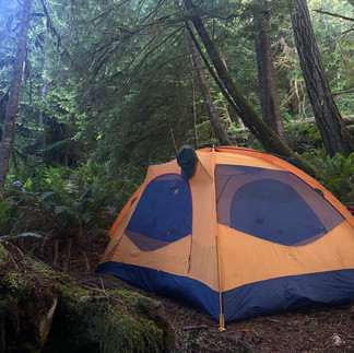
Day 1: Elk Bay Recreation site to Cinque Islands (50.298113, -125.401596), approx. distance: 4.1 km, our campsite rating: okay

A quite small island with just enough space to squeeze in our 4 tents, but the whole service of the island is on a bit of an angle.
Day 2: Cinque Islands to East Thurlow Island (50.445216, -125.324156), approx. distance: 26 km, rating: good

Our highlights of this campsite were the sturdy dock for landing our canoes, a large picnic table for food preparation and consumption, and a surprise addition - fresh shrimp. We bought the shrimp in the morning from a fishing boat that had moored overnight at the dock. The shrimps were flash-frozen on the boat and packaged for immediate market sale, destined for Japan.🍤
Day 3: East Thurlow Island to Stuart Island Recreation Site (50.409286, -125.120093), approx. distance: 18.6 km, rating: very good


This rec site on the east side of Stuart Island was among the top two campsites of our trip. There is a little town (Big Bay) on Stuart Island, so there is more going on here. There is a gravel trail leading across the island all the way to Big Bay on the other side.
Two guys arrived at a quad shortly after us, and it turned out they worked at a fancy fishing lodge with its own airstrip on the island. They returned later bearing gifts of soda, chips, and chocolate, which was a welcome treat considering we considered ourselves quite far away from civilization. 🥤🍫
There is an easy hike up to Eagle lake from the campsite, where we went swimming. The water is a brownish colour from all the tannins coming from coniferous needles but refreshing all the same. The lake lived up to its name as there were at least 20 eagles perched in trees around the lake. 🦅
Attention: To get to our campsite, we paddled through Arran Rapids. We timed that as well as possible, but even just 20 minutes after slack current, there was noticeable current against us. As we navigated through the rapids, someone from a nearby lodge remarked that we were the first canoes they had ever seen passing through.
Day 4: Stuart Island to Rendezvous Islands (50.267880, -125.039456), approx. distance: 24.3 km, rating: good

We actually wanted to camp on the south end of the Rendezvous Islands (which is also an official campsite), but a group of kayakers beat us to it. So we had to turn around and paddle back against the wind to a campsite we had already passed on the north end of the south island. It was still a very good campsite with lots of flat areas and an abundance of fresh oysters. 🦪
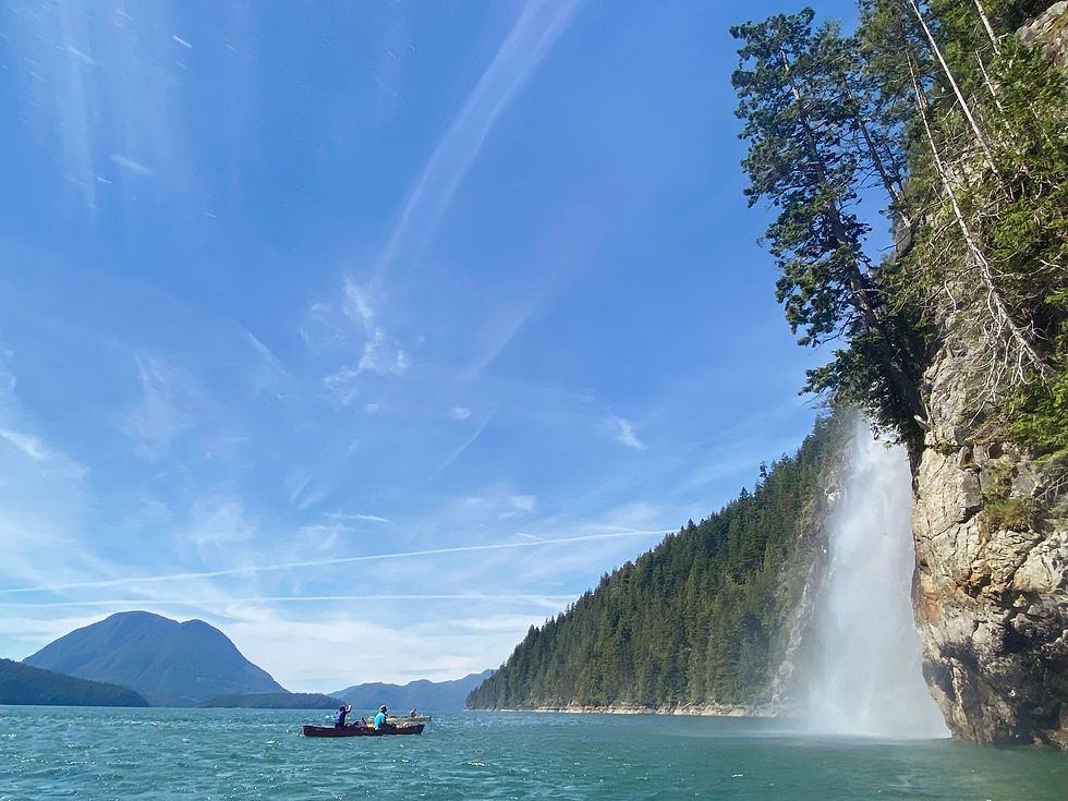
Day 5: Rendezvous Islands to Teakerne Arm Provincial Park (50.198733, -124.847710), approx. distance: 19.5 km, rating: very good


This is a popular anchorage for boaters because of a picturesque view of Cassel waterfall. Every day, people would dock their boat and hike up to take a quick dip in the lake. We camped just off the trail in a big flat area. Not the most private campsite, but it was large enough that we were off the trail. Cassel Lake is a clean, very warm lake and is great for swimming. 🏊🏼
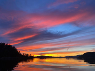
Day 6: Teakerne Arm to Copeland Islands Marine Park (50.02600, -124.82559), approx. distance: 26.1 km, rating: very good

We stayed in the North Copeland Island campsite, and it was very luxurious compared to the rest of the campsites we had been to so far. Amenities include big wooden tent pads, picnic tables, and well-maintained outhouses. However, the beautiful sunset was what really made this campsite stand out. 🌅
You can apply for a backcountry permit on the BC parks website or pay the $5 per person backcountry camping fee in cash.
Day 7: Copeland Islands to Roscoe Bay (50.158446, -124.775055), approx. distance: 20.8 km, rating: good
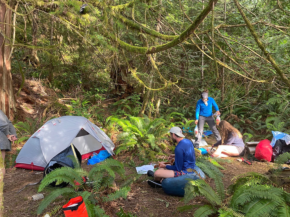
Day 8 (rest day): Roscoe Bay


Roscoe Bay is a popular anchorage for paddlers and sailboats alike. When we arrived, the nice grassy campsites with fire pits were already taken by another group of kayakers. After some scouting around, we ended up camping next to the short trail leading up to Black Lake. It wasn't an ideal location, but we made it work for the night. The following morning, we moved our tents to the actual campsite after the other group had left. Since we decided to take a lay day, most of our group paddled over to the trailhead for a 7.7 km hike up Llanover Mountain. We did lose the trail once while navigating a logging block, but we found it again easily. The lookout at the top gives a great view of the area. 🏞️
Day 9: Roscoe Bay to Gastineau Bay (Toba Inlet) (50.358023, -124.740013), approx. distance: 28.2 km, rating: okay


Toba Inlet is a 35 km long fjord and a great spot to see Grizzly bears, especially further in towards the mainland. We were on the lookout for bears foraging along the shoreline, but we didn’t get a chance to see any on this trip. We also wanted to check out some of the many waterfalls that cascade into the inlet. It took a long time to find this campsite, and we unsuccessfully landed and scouted 2-3 other potential spots first. The campsite didn’t get much light and had a hornet's nest in the middle, but the beach was great for swimming and had a large driftwood log that provided the perfect platform for jumping into the water.
Day 10: Gastineau Bay (Toba Inlet) to West Redonda Island (50.291183, -124.931523), approx. distance: 18.5 km, rating: good
The next day, we saw a nicer campsite with more sunlight and water access just south of this spot (50.289088, -124.935977), but we had enough space for our tents anyway. We even baked a birthday cake with our outback oven that day. 🎂
Day 11: West Redonda Island to Read Island (maybe 50.18462, -125.04997), approx. distance: 17.6 km, rating: not great

On day 11 we finally spotted a whale. 🐋 It was pretty far away, but we were nonetheless amazed and stopped to watch it for a while. The campsite was buggy and had some debris around from an old building. We hadn’t seen any water to collect close by but managed to find a not quite dried up stream by bushwhacking a little bit.
Day 12: Read Island to Peck Island (50.224280, -125.152016), approx. distance: 22.4 km, rating: very good (no water at campsite, so we got water from spring at Hoskyn Channel Landing)


The day we lost our yellow canoe - an unfortunate day with a story to tell. We knew well ahead that Peck Island would be surrounded by the Surge Narrows Tidal Rapids and that again we would need to time our passage at slack current. We had decided to stay the night at Peck Island, so that we could still observe the rapids from the shore. We arrived just as the tide was turning and everything was calm, but we got to observe the current ramp up to a class 2 or 3 rapid all around our little island. As it was winding down again, we jumped in with our PFDs and took the yellow canoe as well. We didn’t realize that the canoe had no bulkheads or flotation of any kind so when it flipped, it promptly sunk, and we never saw it again despite a long time searching to see if it would pop up further downstream. One canoe down...
Day 13: Peck Island to Elk Bay (50.27453, -125.42669), approx. distance: 26.1 km, rating: very good

Luckily, our packs were much smaller since we had eaten most of our food, allowing us to accommodate the extra passengers and gear from the lost canoe among the remaining three canoes. Sitting three in a boat was not that comfortable, so we opted to paddle all the way back to Elk Bay in a single day. There was a tidal rapid at Copper Point that was starting to form as we approached, but it was easily avoided by taking a detour from Diamond Bay to Grand Island, which was a slightly longer narrow, shallow passage with negligible current.
Upon arriving at Elk Bay, it was nice to have ample space to spread out our belongings and enjoy a final meal together before the big farewell. 👋🏼
Why we decided for canoes instead of kayaks 🛶
When it comes to ocean paddling, kayaks offer several advantages over canoes. Kayaks are designed with a lower profile than canoes, making them less susceptible to wind and waves. The shape of a kayak allows it to glide through the water with greater ease and efficiency. We still decided to do our ocean paddling trip with canoes because they offer more storage space, making them ideal for longer trips. From camping gear to food supplies, from fishing rots to outback ovens to extra passengers - we had no issues fitting everything in.


The vast majority of the great photos were taken by our friend and excellent photographer Heather Bonaker-Hofmans. See more of her work here.

